Oceanscience Introduces Surveying in “Elevation Mode” Using RTK GNSS
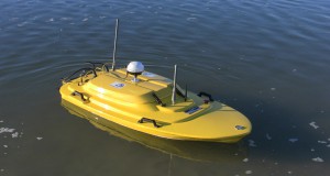
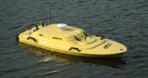
Surveyors wishing to merge hydrographic survey data with land survey data can accomplish this with the Z-Boat 1800.
The Z-Boat acquisition software packages HYPACK(R) and Hydromagic include all the common horizontal co-ordinate grid systems (eg US State Plane, NAD-27, NAD-83, World-UTM) and the ability to enter custom local projections. Depth data from Z-Boat surveys can be expressed as orthometric height referenced to local benchmarks, while surveying in “RTK Tide Mode”.
If the RTK receiver outputs the correct orthometric height this can be used directly in the software. If the receiver outputs MSL based on the standard EGM-96 geoid then this can be corrected to the desired orthometric height in the software using a geoid model. Using Hydromagic software in this case to illustrate:
- RTK elevation measurements are first selected as the source of vertical elevation corrections.
- The GNSS antenna height above the waterline is entered. This allows the software to record the precise water level through the survey.
- The desired geoid model is selected. Elipsoid separation from the GNSS data is used to calculate the elipsoidal height, which is then corrected to the desired orthometric height using the geoid model.
While conducting the survey, depth results are subtracted from the waterline elevation (“RTK TIDE”) to generate the bottom elevation (“CORRECTED DEPTH”) which is orthometric height above MSL as defined by the selected geoid mode.
Press Release, January 27, 2014